


Most drones are unmanned aircraft made of light composite materials to increase movement and reduce weight. Drones can be controlled by a remote control system or ground cockpit. In the unmanned drones, sensors and navigational systems are present. According to dronezon.com, the engineering materials used to build the drone re highly complex composites which can absorb vibration which decreases the noise produced.
Drones can be used for a variety of things such as surveillance, military use, and personal use. Drones are mainly used by commercial institutions. Some broad categories of drone uses include: rescue, marketing, filmmaking, site surveying, parcel deliveries, imaging structures, weather patterns, and policing. Some drones have First Person View (FPV) which means that a video camera is mounted to the drones and allows for live video broadcasting. In the article by Fintan Corrigan, it is mentioned that the FPV controls allows for more precise flying around obstacles where you would not be able to see the obstacles from a fixed position.
Drones have the ability to make deliveries. Today, drones are being used to deliver medical products. Also, after a natural disaster or any catastrophe, drones can be used to get an overall picture of the extent of the damage and is able to find people in distress and allocate resources and send help.
According to Amazon CEO Jeff Bezos he estimates that the drones would have an average delivery time of 30 min and be able to transport up to 5 pounds; all within a 10 mile radius. The package weight range may seem limited, but it does account for about 86 percent of the items Amazon has for delivery.
In December of 2016, Amazon made its first delivery in the United Kingdom. The company has chosen to name the system Prime Air Drone Delivery. While there has be many test private flights, the one in the UK, near Cambridge, England was the first delivery in public air space. Despite Amazon’s recent success in delivering their first package via drone, it still has a long way to go before it can be used successfully on a consistent basis. Due to the drone’s limited flight time and range it will make drone delivery a widespread phenomenon. Most drones are battery powered and as a result have limited use. The max flight time is about 30 minutes and can only be used within a 5-mile radius.
One possible solution is, setting up drone delivery stations where amazon prime member will be able to receive this luxury. The process would be similar in to how AT&T’s U-Verse is only available to people in certain areas. The setting up of these stations would potentially open a new market in which new jobs would be available trained Amazon employees. Amazon could also branch out and collaborate with UPS or FedEx in order to make the stations more centralized and easy to access with the community.
Drones are very limited in use and do not have many flight tests. In the United States, FAA has many regulations on drones. Drones cannot fly above 400 feet above ground and they must be in sight at all times. Drones can’t be operated within 5 miles of an airport with permission of the airport’s control tower.
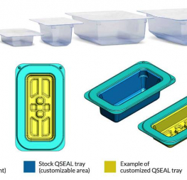
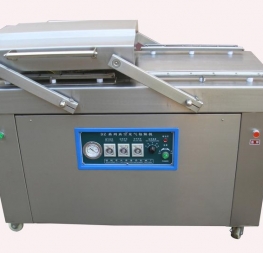
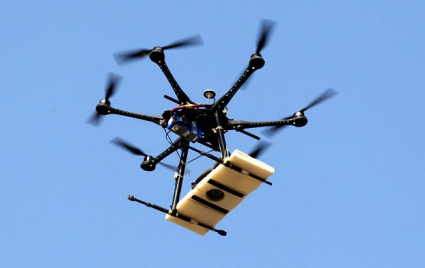
Some drones that are used for package delivery deliver packages with the package on the outside. See Figure 2. This configuration has a lot of risks associated with it. A lot of tests will need to be done to mitigate these risks. ISTA procedures only require packages to be dropped from a max height of 36 inches (3ft). Drones go up to 400 feet above ground so new test procedures will have to be put in place before any deliveries with drone holding the package can be done.
Other applications of drones include: Improved maps, site planning, site modeling, and site surveying. Drones also can enhance security and protection options for a variety of organizations.
In the field of 2 and 3-Dimensional maps, the way drones work can make drastic enhancements. “Drones capture images at very high resolution compared to aerial survey and satellites. For low level flights an individual pixel could be measuring an area as small as one inch square or less; many times more accurate than other sources. Using only still imagery and GPS data, analysis software can stitch the photos together to produce full color, photo realistic 3D datasets that provide immersive visualization and powerful analytics. You get a video game-like visualization experience that allows the viewer to fly around the model, exploring any part of it from any angle and the ability to measure any part of it.”
These functions can be used to give the most up to date visuals of the world. Thus, 2D maps could be me made much more efficiently and 3D map programs will becomes much more accurate.
Diving drones into the world of site modeling, planning, and surveying also can make a great impact. “Drone flight post processing and mapping software lets operators calculate lengths, heights, areas and volumes without resorting to expensive and complicated ground surveys. A drone with suitable cameras, can survey a building or site in under an hour producing a terrain surface from which you can calculate and measure cut and fill volumes, slopes and aspect. This lets you estimate potential engineer work requirements and costs and see the impact using the same 3D visualizations described above.” Surveys via drone can expose hidden geographic features that aren’t easily seen due to vegetation or other natural native terrains. Drones can also explore more area than traditional surveying could, easily capturing the surroundings of the desired area. They have easier access too hard to survey terrains like streams and culverts.
The surface of the true potential of drones has only been scratched. As drones are improved, simplified and are made more sophisticated, between its hardware, software, and control systems they will begin providing huge improvements all fields. Package delivery and the idea of flying warehouses are simple applications that are driving real innovation and financial benefit.
References
www.dronesglobe.com
www.dronezon.com
www.howtogeek.com
www.usnews.com
http://oakridgeobserver.com
http://nypost.com
https://www.shutterstock.com
http://doctordrone.com.br